Wuhan.LuoJiaNET and LuoJiaSET jointly built by Wuhan University and Huawei are officially launched in MindSpore community. Here, we sincerely invite experts in the field of remote sensing and remote sensing enthusiasts to try out, leaving your valuable suggestions for the prosperity and development of the remote sensing industry.

For a long time, the remote sensing applications have been altering from day to day and the remote sensing industries have been developing vigorously. However, in the development of remote sensing intelligent interpretation applications, experts are often limited by the characteristics of general deep learning frameworks. These characteristics include the following aspects: they can only handle the samples with small size, and the categories of the sample are few, and the scales and channels are limited. Therefore, researchers are increasingly eager for a deep learning framework dedicated to the field of remote sensing. This framework has the following characteristics: they can handle the large-sizedsamples with rich categories, and these samples have a widely range of scale changes and diverse channels.
With the support of the major research program integration project of the National Natural Science Foundation of China, Wuhan University and Huawei 's MindSpore framework team jointly developed the world 's first deep learning framework for intelligent interpretation of remote sensing images, Wuhan.LuoJiaNET, and the largest remote sensing image samples library, LuoJiaSET, which were released in Huawei MindSpore Community. Under the guidance of Professor Jianya Gong, an academician of the Chinese Academy of Sciences, a core research team was established for the project. Professor Xiangyun Hu is the leader of the team, associate researcher Mi Zhang is the overall technical leader of LuojiaNET, and associate researcher Liangcun Jiang is the overall technical leader of LuoJiaSET. In addition, the team also recruited a number of young and middle-aged academic backbones, they come from School of Remote Sensing Information Engineering, State Key Laboratory of Surveying, Mapping and Remote Sensing and School of Computer Science of Wuhan University. Wuhan.LuoJiaNET provides a new deep learning framework and five basic remote sensing application models including remote sensing scene classification, target detection, ground object classification, change detection, and multi-view three-dimensional reconstruction. LuoJiaSET provides an extensible large-scale sample set for remote sensing interpretation. Which can provide a domestic manufacture, independence and controllability convenient tool with "full stack" for the application and development of remote sensing.
1.'Full Stack' Deep Learning Architecture

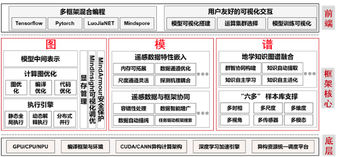
Aiming at the application requirements with multi-level task of "scene-target-pixel" for remote sensing images, starting from the bottom frame, taking the computational flow graph (graph) as the center, taking into account the characteristics of remote sensing detection mechanism model (model) and geoscience knowledge graph (spectrum), and deeply integrating with the full-scene AI framework MindSpore. Finally, LuoJiaNET, which is a special framework for intelligent interpretation of remote sensing images with the fusion of 'graph-model-spectrum' has been formed.
2. Multidimensional Remote Sensing Characteristic Design
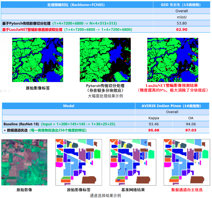
LuoJiaNET which is a special remote sensing framework also takes full account of the characteristics of multi-dimensional temporal and spatial spectrum. In order to meet the requirements of efficient and flexible automatic memory expansion, adaptive optimization of scale and channel, the multi-dimensional application design which is in line with the characteristics of remote sensing has been completed. LuoJiaNET can support CPU, GPU, NPU and other hardware devices. For example, in large size processing, the distributed computing method of operator equivalent decomposition is used to directly process the whole large size remote sensing image. In the channel selection, the data channel adaptive optimization module is used to classify hyperspectral remote sensing images directly. For another example, a large number of experiments show that the classification performance of deep networks can be significantly improved under the guidance of multiple remote sensing empirical knowledge models such as vegetation index, drought index, building index, and terrain index.

3.Establish a Unified Classification System
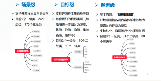
Starting from the current situation, in view of the commonly problems existed in the sample database, such as "inconsistent classification system, single sensor type, weak model generalization ability", LuoJiaSET is the largest remote sensing image sample dataset in the industry that meets the OGC standard.

The goal of Wuhan.LuoJiaSET is to establish a unified classification system for different remote sensing tasks, forming the collection requirements,
content and process specifications of sample elements, which can support the collection, production, management, sharing and application of multi-level
and multi-type remote sensing image sample libraries, and greatly improve the efficiency of image annotation.
Welcome to the online experience of Wuhan.LuoJiaNET ang LuoJiaSET, and put forward valuable opinions and suggestions !
Link entry guidelines for related tests :
1 LuoJiaSET service platform
( Can be accessed as a guest ) : http://58.48.42.237/luojiaSet
2 LuoJiaNET service platform
( Can be accessedafter registration ) : http://58.48.42.237/luojiaNet
3 LuoJiaNET source code, can be accessed through the following URL :
→ https://github.com/WHULuoJiaTeam/luojianet
→ https://gitlab.com/whuluojiateam/luojianet
→ https://bitbucket.org/luojiateam/luojianet
→ https://try.gitea.io/LuoJiaTeam/luojianet
